Call us at: +353 (0)56 776 6868
Share on FacebookWalk from Thomastown to Inistioge
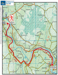
 The Irish Examiner recently featured the Thomastown to Inistioge walk. This is a lovely walk of abut 11km. The walk normally takes about 2 hours and there are no hills.
Thomastown was a walled Norman settlement, enclosing a substantial castle built by Strongbow’s son-in- law in the 13th century. Parts of the fortifications of the town still exist either site of the of the bridge in the town.
There is plenty of parking in the town and the easiest place to start the walk is from the GAA pitch, reached by driving south across the bridge on the N700.
From the Irish Examiner:
We take the first left (for Tullagher) and the next left into Castle Avenue, between houses, and through gates to the pitch. The 13th century Grennan Castle, in ruins, stands on the riverbank nearby. Besieged in 1650 by Cromwell, it remained intact until 19th century builders pillaged the stonework.
After parking, we walk right to a stile, then across a field to a second stile, then to a path beside the Nore, an EU-designated salmonoid river. The stretch we walk is especially noted for its salmon and trout fishery. The river also holds lampreys, a rare, eel-like fish, crayfish and otters. Daubenton’s bats roost under bridge arches.
We are directed right onto the small road, where we then go left.
After about 1km of this wooded road, a post with a green arrow directs us along a lane into Dysart woods. Below, on the river bank, is Dysart Castle, in ruins.
Bishop George Berkeley, the philosopher who posed the interesting question, are objects there if we do not perceive them?’, was born nearby. Dysart woods nurture wood anemones, bluebells and primroses in springtime. Speckled wood butterflies spiral in the clearings between hazels, holly and tall ferns.
We cross a stone bridge over the Arrigle River, rushing to join the Nore. Downstream is an attractive white house with trees and an old building behind it, perhaps once a mill. We pass a waymark and go, left signposted Inistioge, at the crossroads beyond. At a green arrow and wooden stile, we can leave the road again for a short distance. Emerging, we go left and descend to broad Brownsbarn Bridge. We do not cross but continue, past the waymark, and onto the R700, where signs warn walkers to take care. However, after 0.5km, alongside a sign on the left saying Trail Kilkenny, a stile leads to a path going down to the river bank. No more road now; following the river’s meanders, we walk a grassy bank-side track along the field bottoms all the way to Inistioge. The opposite bank is tree-lined.
Coming in sight of Inistioge, we see the magnificent 10-arched bridge ahead and, passing through a kissing-gate and a bridge over a millstream, we cross a riverside park, with picnic tables and a signboard relating the rich history of the town. Immediately upon turning right to reach a street, we pass the stump of a ruined castle (The Hundred Court, I believe) and can see a church, with a castellated tower, in the town.
The Annals of the Four Masters relate that in 962AD, the Ossorians slaughtered many Danes in a battle at Inistioge. The village green was created by the Tighes, whose Woodstock demesne retains an arboretum and gardens open to the public in springtime; the house was burnt in 1922. A memorial obelisk, dated 1621 and a fountain, 1878, are features. Also, among Inistioge’s heritage is a Norman motte of 1169 (no access), the remains of the 13th century Augustinian Priory and St Columba’s Well.